-->
:
:
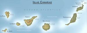
CANARY ISLANDS- ISLAS CANARIAS- KANARISCHE INSELN | |||||||||||||||||||||||||||||||||||||||||||||||||||||||||||||||||||||||||||||||||||||||||||||||||||||||||||||||||||||||||||||||||||||||||||||||||||||||||||||||||||||||||||||||||||||||||||||||||||||||||||||||||||||||||||||||||||||||||||||||||||||||||||||||||||||||||||||||||||||||||||||||||||||||||||||||||||||||||||||||||
BLOG/ Startseite
March 17- 31- 2014
| |||||||||||||||||||||||||||||||||||||||||||||||||||||||||||||||||||||||||||||||||||||||||||||||||||||||||||||||||||||||||||||||||||||||||||||||||||||||||||||||||||||||||||||||||||||||||||||||||||||||||||||||||||||||||||||||||||||||||||||||||||||||||||||||||||||||||||||||||||||||||||||||||||||||||||||||||||||||||||||||||
 |
Activity report here will ony follow, if new events take place. For other environmental reports, please visit the solar and terrestrial blog on my homepage
------------- ACTIVITY REPORTS:MARCH 30- 31- 2014: magmatic intrusion from the hot spot below El Hierro continued on low level with on quake per day. The epicenter of the first quake was again in the Valle del Golfo. The second on March 31 occured on the Southern peak of the island near El Pinar, where the main activity took place in 2011. This quake also was the first one in a lower depth of 10 km within this latest activity period. that started in March 2014
HARMONIC TREMORS are still present on all island and are still relatively highest on Gran Canaria and the eastern islands. During March 30the tremor signal also increased on La Palma and is second highest there on March 31:  < La Palma/ 20140331 < La Palma/ 20140331
VOLCANO NEWS IN OTHER PARTS OF THE WORLD
YELLOWSTONE CALDERA
Frist time observed in recent history, an entire earthquake swarm occured directly within the Yellowstone caldera . Single magmatic quakes there became more and more frequent since 2011 as well as nearby to the National Park with about 1- 2 quakes per year , what nevertheless is considered to a true sign of new magma intrusion from the hot spot below.
. But the Magnitude 4.8 event on March 30 is the strongest measured since more than 30 years, At all, 5 quakes ( M 2,5, M 3.1, M 3.3, M 3.1) occured there from 12 UTC- 15 UTC on March 30, whereby the first was the strongest I don`t know when such a strong activity was ever observed since the Yellowstone park has one of the densest observation stations in the world. No more quake on March 31 what means nothing, since those quakes occure only as long as updwelling magma finds any restistance.

A view on the "old faithful" wevcan yesterday showed strange scenes, While usually only one or two fissures there emit regularly steam there, numerous other sources of steam emissions appeared there yesterday- some just in between the first trees . Interestingly -numerous an different animals living in the park gathered yesterday around the old faithful geysir as if they would hold a conference there...I have recorded these images and will publish them on youtube as soon I will have some more interesting scenes
INCREASED SEISMIC ACTIVITY NEAR THE SAN ANDREAS FAULT
mainly the greater los Angeles area continues and peaked with another M 5.1 quake near Los Angeles on March 29 , that rattled sone houses but left no significant damage there. Seismic activity along the SAF significantly had increased end of 2013 and became a regular earthquake swarm since January 08 2014. Since then the activity seems by and by slowly to increase. Most experts however believe, that this seimic activity is just the prelude for an massive and possibly catastophic major quake there.

EIFEL VOLCANO FIELD ( region around LACHER LAKE) near Koblenz/ Germany
Also tremor activity in the with more than 35 km (estimatable only !!!) deepest hot spot/ mantle plume system in the world increased over the past years with about 1 quake per year within the central volcanic region around the Lake of Laach and at least 3- 10 quakes per year in the wider region of 50- 300 km) around . 2012 I had marked these quakes in a map and they formed a wide circle around the Eifel volcano field, what must NOT NECESSARILY mean, that these minor tremors are related a to any volcanic activity there.

In reality- resp as volcano research shows, almost no volcano ever comes to a final stillstand, and also the activity below the Eifel caldera - though on low level anyway- has increased over the last years. The Eifel volcano field has certian characteristics. Its lower magma chamber ( if it has one) or what may be rather a large and widened mantle plume is estimated to be deep in the European Earth crust, which is for itself the most massive one on Earth. There is magma active in the system, that likely melts calciumcarbonates ( a very common rock consisting out of Calcium and Carbondioxide( acid ) in the depth, what then ( similar to cement production) creates the typical carbondioxide emission observed with the Laacher lake and the regions around.
Allthough The Eifel volcano field is likely the most passive hot spot system on Earth, its produced around 11.500 B C the latest know supervolcano eruption in history.
---------- MARCH- 27- 29- 2014: Activity below El Hierro temporarily increased on March 27 with 2 quakes . The average depth of the quake remained with 15 and 20 km unchanged with no sign of an upcoming surface activity so far.... The 3. quake in the "Atlantico" took place between Teneriffe and Fuerteventura , and is part of tectonic activities in a larger scale. But its depth is again unknown yes resp. was not told by IGN. 
TREMOR ACTIVITY is still relatively highest on Gran Canaria and La Gomera, as well as on the eastern islands, but low on all the other islands:  < La Gomera/ 20140330 < La Gomera/ 20140330
SOLAR ACTIVITY: STILL FREQUENT SEPs (solar energetic protons) , while overall solar activity has decreased after the 11 years peak in 2013
Its part of my research, that hot spot activities expecially increase during and after major but usually rather SELDOM solar proton storms ( SEP) , as also all activities on the hot spot below El Hierro were related to resp occured imidiately after and during a solar proton storm.Protons storms can last for several hours to several weeks, and are usually followed by long lasting electron accumulations the earth attrackts then with its additional proton load from the solar interplanetary magnetic filed above. These electrons than accumulate above the Northern pole, where they can create among other effects such as strong thunderstorms and tornadoes , but also strong heat effects , those typically can last over 3- 4 weeks.
 < minor increase on solar proton flux on March 29. its a rather weak event that will have some but NOT have major effects < minor increase on solar proton flux on March 29. its a rather weak event that will have some but NOT have major effects
ELECTRONS AND PROTONS
With more frequent solar SEPs observed during the past years . this electron activity ( the counterparts to the Protons- both particle types strongly interact with one another) activity was always knocked down and likely compressed by new proton events: Just on March 29, the electron activity knocked down by recent larger and minor proton began to recover from recent long duration proton impacts that part occured weks ago:
 < electrons within the geomagnetic field/ 20140328- 30 < electrons within the geomagnetic field/ 20140328- 30
Two minor rather week ones occured just on March 26 and 29. Protons emitted during an X 1 flare SEP event in solar region 12017 reached an initial speed of about 37.000 kilometers per second. the events seems aith a proton density below 1 pfu. rather minor . but still ongoing any might last longer than ther very weak event on March 25. You find regular updates in my solar and terrestrial blog
SCIENTISTS STILL EXPECT LARGER QUAKES FOR THE LOS ANGELES REGION:
Also, the seismic activity in the region of the St Andreas fault that began tio increase after January 08 2014, is still going on and peaked in the past days again with a magnitude M 5.1 quake in the greater Los Angeles area on March 29 . Only minor damage was reported.

On March 26 another magmatiuc quakje was measured directly in the Yellowstone National park in Wyoming, Single quakes had been observed there from time to time ( aboiut 1 quake in 2- 3 month) since several years , but became rather more frequent since January 2014 with two or three quakes since then.
 ---------- MARCH- 25- 27- 2014: Magmatic earthquake activity below El Hierro continued in a low pace of 1 - 2 quakes per day. The last major magma boost seems to be over
HARMONIC TREMORS continued also on all islands, but were some weaker during the past days. Tremors are still relatively highest on Gran Canaria, La Gomera and Teneriffe:  < GranCan/ 20140327 < GranCan/ 20140327
MODIS/ Thermal alerts.
Heat signature shows still significant warming on the islands. The red colorisatoion on El Hierro, la Palma, and La Gomera has slightly increased after the last magma boost:
 ------------------ MARCH- 23- 24- 2014: magmatic activity continued on low level on March 22 until 24
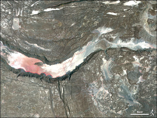
HARMONIC TREMORS increased on all island and are currently relatively highest on Gran Canaria and La Gomera:  < Gran Can/ 20130423 < Gran Can/ 20130423The liftup process on El Hierro- caused by the expansion forces in the uprising magma- came to a stillstand and remained at the new level it reached during the last days activity. THe ongoing activity below El Hierro is- so the most probably theory imaginable as shown in the graphic (by Motilla) below . Its simply not possible to explore the deeper formations below the islands by any technical means . Similar to the theory about the Yellowstone caldera , all theory based on availabe data - mainly 3 D models of the quake activity in the mantle plume ( there is no earthquake from an theoretical magma chamber, as magma flowing into such an hollow space just would not find much resistance). The estimated location of the magma chamber is thererfore is defined as the hollow space between the earthquake locations and in fact " visible"or present on the 3 D animation (The western Canary island sit on the edge of a former huge shield volcano that once has reached to the coast of maroc , but collapsed and/ or was almost totally destroywed after a major eruption at any historical time that finally left just a broken and lose caldera that was later covered with sediments brought along by the sea currents. If no magma chamber exists anymore , also no pressure can built up ( mainly by contact with water/ steam) that would be necessary for a significant surface eruption. Instead- and due to tha fact that the region is a spreading zone- the magma likely currently (and since the begin of the new activities) fills up hollow spaces, old trenches and faults below the archipelago, with a chance that a minor upper cave might serve as a minor magma chamber and pressure that builts up in there ( by steam) might press the magma finally to the surface:  The other- and not so pleasant- idea along with that - is a larger bubble of magma that formes out below the archipelago,and that might reach an dangerous size at any time Another theory is based on the Yellowstone research and asasumes that those hot spot systems might have a SECOND more or less large magmachamber in a depth of 10 km and more that neverlessless cannot be localised by any technical means today .So its just theory., --------------
MARCH- 20- 22- 2014:
Only one quake from the mantle plume below El Hierro on March 20: New Magma intrusion obviously came to a stillstand.
 TREMORS: Harmonic tremors are weak on all islands. Just Gran Canaria has stronger tremors accomponied by any form of (electric?) distortion:  < GranCan/ 20140322 < GranCan/ 20140322-------- MARCH- 18- 19- 2014 the new magma boost further decreased on March 18- 19 with only two quakes in the past 3 days:
New deformation data for El Hierro were published by IGN in Spain : The new data show that the sheer unbelievable graviational expansion forces in the magma rising up from the hot spot at the edge of the outer Earth mantle in about 40- 60 km depth again lifts up- this time- the western part of El Hierro North and South from the epicenter of the recent earthquake swarm in the Valle d`el Golfo.( LA FONTERA): symbols in the graphic explained:( "u" means" upward"- "n" northwards and e" eastwards movement . (Negative values mark a movement into the opposite direction)H01=H10 stand for the single GPS stations on the island of El Hierro ( established after the new activity began in 2011) . (You find in the GPS map in the column left ) 1. GPS stations H01- H05 on the southwestern part of the island near valle d`el Golfo) 
1. GPS stations H06- H10 on the South and southeastern part of the island . near El Pinar, were the first and only surface eruption yet had occured end of 2011:
 ------------------------ MARCH- 17- 18- 2014: The new earthquake activity and related magmatic intrusion below El Hierro was decreasing on March 17 and 18 and seems to be over for now:
TREMOR:
Tremor intensity was slightly increasing on all islands due to the new hot magma intrusion below the island, but is still moderate and is still relatively highest on Gran Canaria:
 | | |||||||||||||||||||||||||||||||||||||||||||||||||||||||||||||||||||||||||||||||||||||||||||||||||||||||||||||||||||||||||||||||||||||||||||||||||||||||||||||||||||||||||||||||||||||||||||||||||||||||||||||||||||||||||||||||||||||||||||||||||||||||||||||||||||||||||||||||||||||||||||||||||||||||||||||||||||||||||||||||
REAL TIME FEATURES:
(click on the images to enlarge them)  Bebenmap( El Hierro)  GPS deformation measure stations on El Hierro  MODVOLC/ Hawaii thermal alerts: ^ near real time thermal alert for El Hierro, la Palma, Teneriffe and la Gomera ( updated once per week) volcano discovery. com : Earthquake within 30 km radius around El Hierro: 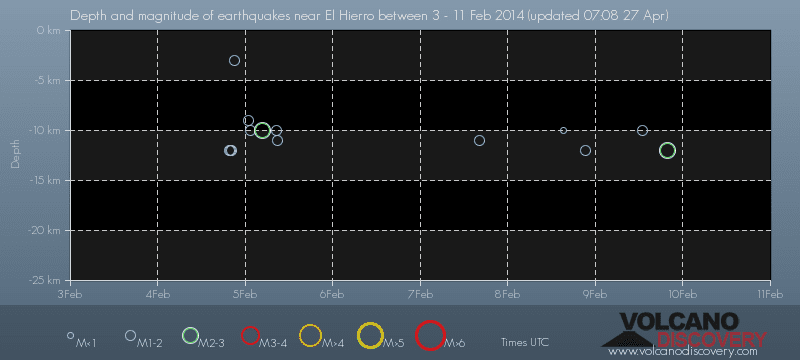 ------- --------------- previous posts those contain articles about the Canary volcanism in general:February 10- 16- 2014 January 15- 19- 2014 January 20- 27- 2014  Mnt Teide ( Teneriffe) related free online sources:VOLCANOES: "Eruptions that shook the world" a very interesting and freely avaible source how volcanoes work where you find all what you want to know about volcanoes Sources of the volcanic activity at El Hierro ( since 2011): Some may like to read a review on the volcanic activity below El Hierro in 2011: Here is a data based report by earthquake .com- an excellent site regularly reporting (what you never get in the news) about Earthquakes and related volcanism worldnews.com: Special environmental reports about the Canaries Miscanellous: Geschichte Teneriffas (deutsch)  Fataga ( Gran Canaria)  San Cristóbal de La Laguna in 1880 (Tenerife)  Caldera de Taburiente National Park (La Palma).  Garajonay (La Gomera)  (BBC/ 20111204)Canary Island volcano: A new island in the making? | |||||||||||||||||||||||||||||||||||||||||||||||||||||||||||||||||||||||||||||||||||||||||||||||||||||||||||||||||||||||||||||||||||||||||||||||||||||||||||||||||||||||||||||||||||||||||||||||||||||||||||||||||||||||||||||||||||||||||||||||||||||||||||||||||||||||||||||||||||||||||||||||||||||||||||||||||||||||||||||||||