-->

letztes Beben(Kanarische Inseln ( IGN)

Bebenmap( El Hierro)

GPS deformation measure stations on El Hierro
MODVOLC/ Hawaii thermal alerts:
^
near real time thermal alert
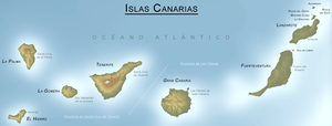
for El Hierro, la Palma, Teneriffe and la Gomera ( updated once per week)
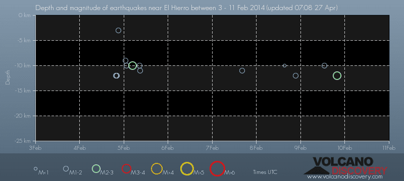
volcano discovery. com : Earthquake within 30 km radius around El Hierro:
-------
---------------
February 10- 16- 2014
January 15- 19- 2014
January 20- 27- 2014

Mnt Teide ( Teneriffe)
VOLCANOES:
"Eruptions that shook the world"
a very interesting and freely avaible source how volcanoes work where you find all what you want to know about volcanoes
Sources of the volcanic activity at El Hierro ( since 2011):
Some may like to read a review on the volcanic activity below El Hierro in 2011:
Here is a data based report by earthquake .com- an excellent site regularly reporting (what you never get in the news) about Earthquakes and related volcanism
worldnews.com: Special environmental reports about the Canaries
Miscanellous:
Geschichte Teneriffas (deutsch)

Fataga ( Gran Canaria)

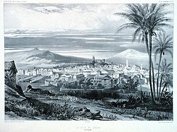
San Cristóbal de La Laguna in 1880 (Tenerife)

Caldera de Taburiente National Park (La Palma).

Garajonay (La Gomera)

(BBC/ 20111204)Canary Island volcano: A new island in the making?
:
:
CANARY ISLANDS- ISLAS CANARIAS- KANARISCHE INSELN | |||||||||||||||||||||||||||||||
 BLOG/ Startseite | |||||||||||||||||||||||||||||||
| internal links > | START | HOME | SOLAR BLOG | VOLCANO WATCH | VOLCANO MAPS | external links > | IGN | AVCAN | AVCAN/ fb. | EMSC | GVP | NOAA |

Activity report here will ony follow, if new events take place. For other environmental reports, please visit the solar and terrestrial blog on my homepage
update/ 20170827:
On the website of a German Volcanologist I now ( some days ago) found a surprising article form its author Marc Szeglat. I just copy now and post in german as this website is only in German language:
Auf der Kanareninsel Teneriffa sind Seismik und Kohlendioxidausstoß der Vulkane erhöht. Am Samstag ereignete sich ein Erdbeben der Magnitude 3,3. Es war das stärkste Erdbeben einer Serie von insgesamt 59 Beben innerhalb eines Monats. Ansonsten bebt es deutlich weniger auf den Kanaren. Die Beben manifestieren sich zwischen Teneriffa und Grand Canaria. Zudem wurden am Cumbre Dorsal auf Teneriffa 3-fach erhöhte CO2 Emissionen nachgewiesen. Diese Daten bedeuten allerdings nicht, dass in der Ferienzeit ein Vulkan auf der beliebten Urlaubsinsel ausbrechen wird.
Gasausstoß auf La Palma
Eine weitere Kanareninsel steht heute in den Schlagzeilen: auf La Palma wurde der CO2-Ausstoß aller Vulkane von INVOLCAN gemessen. Dabei fand man heraus, dass die Feuerberge täglich 800 Tonnen CO2 ausstoßen.(find more at Vulkane Net Newsblog
In English, the article says, that activity has risen on Teneriffe / Teide) with some new seismic quakes ( rather usual and rather getting less and less in the past years ) but also a first resp "increased" Carbondioxid emission measured by AVCAN and IGN, which is the first surface activity reported by IGN and AVCAN since the second activity phase began in Dezember 2012.
Nevertheless that author stresses, that currently no danger must be feared and volcanic eruptions would be expectable , when most tourists visit to make holidays on the islands.
In August 2017 the carbon dioxid emission measured at Cumbre Dorsal was three times higher than usually .
Also the the remote island of La Palma- so the article was in the news since AVCAN found out , its volcanic features emit daily an amount of 800 tons of carbondioxide
-------------
update/ 20170827:
Its long time ago that I made any update here.
The first reason is, that due to the fact that we are going to get to the 11 years sun spot minimum in 2018/ 19 : flare activity has decreased and we had just one real proton event /(SPE ) in the last years and that was recently in June 2017.
Nevertheless, he activity on all known and monitored hot spots has significantly decreased in the last years, magma intrusion from the hot spots seem to have stopped . The uprising magma has completed its expansion with the highest microquake recoireded so far 32 km below Teneriffe in 2016. The amounts of Magma accumulated near hot spots even seems currently having begun to cool down and harden out .
Neverthelesse there are microquake swarms with increased seismic activities mostly in the Yellowstone park., where the a magnitudes slightly rise year by year .
The destructive earthquake in Central Italy and as on Auguist 25 also on the volcanic island of Ischia in the Gulf of Neapel might by caused by the contraction of accumulated Magma , that had before lifted up trhe landscapes there . This slight contraction might create hollow spaces in the underground , those now likely would collapse under the weight of the earthcrust/ formation above.
The second reason why I could not make more updates was that the website with the seimic data at AGN was no more available since 2016 , ass I first thought - due to some problem or due to the policy of the Spanish authorities to avoid anything what might scare tourist not to visit the islands anymore. And without data the volcanic system is just silent.
However :Meanwhile its is available again in a new format and from another server and I have just updated the links in the header and the left colum..
However: Still nothing happened on the surface yet more than the uplift ( January- February 2017) and some earthquakes that caused rockfalls on El Hierro.
The spanish civil protection has exercised emergency operations on Teneriffe / Teide system that played in the year 2024, when _ as I also would suppose- hot spot activity likely will resume on The Canary hot spot as on all hot spots worldwide due to the next 11 year sun spot maximum with new solar Proton events (SPE) ( 2024/25. I rather sould suggest , activityies form hotm spots ( new magmaintrusion) will begin already some years earlier ( from about 20122 on) as it did also during the last 11 years maximum ( The first activity phase below El Hierro started in June 2011)
update/ 2017-08- 27:
On the website of a German Volcanologist I now ( some days ago) found a surprising article form its author Marc Szeglat. I just copy now and post in german as this website is only in German language:
Auf der Kanareninsel Teneriffa sind Seismik und Kohlendioxidausstoß der Vulkane erhöht. Am Samstag ereignete sich ein Erdbeben der Magnitude 3,3. Es war das stärkste Erdbeben einer Serie von insgesamt 59 Beben innerhalb eines Monats. Ansonsten bebt es deutlich weniger auf den Kanaren. Die Beben manifestieren sich zwischen Teneriffa und Grand Canaria. Zudem wurden am Cumbre Dorsal auf Teneriffa 3-fach erhöhte CO2 Emissionen nachgewiesen. Diese Daten bedeuten allerdings nicht, dass in der Ferienzeit ein Vulkan auf der beliebten Urlaubsinsel ausbrechen wird.
Gasausstoß auf La Palma
Eine weitere Kanareninsel steht heute in den Schlagzeilen: auf La Palma wurde der CO2-Ausstoß aller Vulkane von INVOLCAN gemessen. Dabei fand man heraus, dass die Feuerberge täglich 800 Tonnen CO2 ausstoßen.(find more at Vulkane Net Newsblog
In English, the article says, that activity has risen on Teneriffe / Teide) with some new seismic quakes ( rather usual and rather getting less and less in the past years ) but also a first resp "increased" Carbondioxid emission measured by AVCAN and IGN, which is the first surface activity reported by IGN and AVCAN since the second activity phase began in Dezember 2012.
Nevertheless that author stresses, that currently no danger must be feared and volcanic eruptions would be expectable , when most tourists visit to make holidays on the islands.
In August 2017 the carbon dioxid emission measured at Cumbre Dorsal was three times higher than usually .
Also the the remote island of La Palma- so the article was in the news since AVCAN found out , its volcanic features emit daily an amount of 800 tons of carbondioxide
-------------
GOOGLE BLOG ARCHIVE |
Seitenzahl: 03 |
| Latest Post |
| BLOG START/ NAVI |
useful links/ nützliche Links: |
| EMSC |
| Global Volcanism Program |
| Facebook Seite der AVCAN |
| IGN (Spain) Serie El Hierro |
| Volcano-discovery.com |
| Earthquake- report. com |
MEDIEN: |
KARTEN: |
SOLAR (SAT) |
SOLAR (info) |
REAL TIME FEATURES:
(click on the images to enlarge them)
(click on the images to enlarge them)

Bebenmap( El Hierro)

GPS deformation measure stations on El Hierro
MODVOLC/ Hawaii thermal alerts:
^
near real time thermal alert
for El Hierro, la Palma, Teneriffe and la Gomera ( updated once per week)
volcano discovery. com : Earthquake within 30 km radius around El Hierro:
-------
---------------
previous posts those contain articles about the Canary volcanism in general:
February 10- 16- 2014
January 15- 19- 2014
January 20- 27- 2014

Mnt Teide ( Teneriffe)
related free online sources:
VOLCANOES:
"Eruptions that shook the world"
a very interesting and freely avaible source how volcanoes work where you find all what you want to know about volcanoes
Sources of the volcanic activity at El Hierro ( since 2011):
Some may like to read a review on the volcanic activity below El Hierro in 2011:
Here is a data based report by earthquake .com- an excellent site regularly reporting (what you never get in the news) about Earthquakes and related volcanism
worldnews.com: Special environmental reports about the Canaries
Miscanellous:
Geschichte Teneriffas (deutsch)

Fataga ( Gran Canaria)

San Cristóbal de La Laguna in 1880 (Tenerife)

Caldera de Taburiente National Park (La Palma).

Garajonay (La Gomera)

(BBC/ 20111204)Canary Island volcano: A new island in the making?


Keine Kommentare:
Kommentar veröffentlichen