-->
letztes Beben(Kanarische Inseln ( IGN)

Bebenmap( El Hierro)

GPS deformation measure stations on El Hierro

MODVOLC/ Hawaii thermal alerts:

^
near real time thermal alert
for El Hierro, la Palma, Teneriffe and la Gomera ( updated once per week)
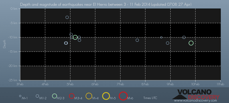
volcano discovery. com : Earthquake within 30 km radius around El Hierro:
-------
---------------
February 10- 16- 2014
January 15- 19- 2014
January 20- 27- 2014

Mnt Teide ( Teneriffe)
VOLCANOES:
"Eruptions that shook the world"
a very interesting and freely avaible source how volcanoes work where you find all what you want to know about volcanoes
Sources of the volcanic activity at El Hierro ( since 2011):
Some may like to read a review on the volcanic activity below El Hierro in 2011:
Here is a data based report by earthquake .com- an excellent site regularly reporting (what you never get in the news) about Earthquakes and related volcanism
worldnews.com: Special environmental reports about the Canaries
Miscanellous:
Geschichte Teneriffas (deutsch)

Fataga ( Gran Canaria)
San Cristóbal de La Laguna in 1880 (Tenerife)

Caldera de Taburiente National Park (La Palma).

Garajonay (La Gomera)

(BBC/ 20111204)Canary Island volcano: A new island in the making?
:
:
CANARY ISLANDS- ISLAS CANARIAS- KANARISCHE INSELN | |||||||||||||||||||||||||||||||||||||||||||||||||||||||||||||||||||||||||||||||||||||||||||||||||||||||||||||||||||||||||||||||||||||||||||||||||||||||||||||||||||||||||||||||||||||||||||||||||||||||||||||||||||||||||||||||||||||||||||||||||||||||||||||||||||||||||||||||||||||||||||||||||||||||||||||||||||||||||||||||||||||||||||||||||||||||||||||||||||||||||||||||||||||||||||||||||||||||||||||||||
BLOG/ Startseite
JUNE 01- 30- 2014
| |||||||||||||||||||||||||||||||||||||||||||||||||||||||||||||||||||||||||||||||||||||||||||||||||||||||||||||||||||||||||||||||||||||||||||||||||||||||||||||||||||||||||||||||||||||||||||||||||||||||||||||||||||||||||||||||||||||||||||||||||||||||||||||||||||||||||||||||||||||||||||||||||||||||||||||||||||||||||||||||||||||||||||||||||||||||||||||||||||||||||||||||||||||||||||||||||||||||||||||||||
 |
Activity report here will ony follow, if new events take place. For other environmental reports, please visit the solar and terrestrial blog on my homepage
------------- as first report for June-
very good video about volcanism in the AFAR triangle I found on youtube: The african plate is just the aneighbored plate to the Canary islands and plate movements there have much influence on the Canary Islands.
^part 1 ^part 2 ^part 3 ACTIVITY REPORTS/ JUNE 01- 30 2014:JUNE- 20- 30 - 2014JUNE 30- 2014:
Another quake - propably a volcanic inflation- occured on June29 near a seamount between Teneriffe and Gran Canaria-. The seamount has no crater yet, but is suspected - or wished by the experts to become another volcano or volcanic islands .

This activity again followed another short magmatic boost below El Hierro on June 26- 28. resp. three more - likely volcanic- quakes below El Hierro on June 26- 28:
Not much happened anymore in the second part of June 2014- after what was- due to an expert most likely a " volcanic deflation"- following the first observed "inflation" below Teide in May 2014.
------------
JUNE- 18- 2014
another- as AVCAN still hopes " isolated phenomenon of " volcanic activity below the Teide Massiv on Teneriffe on July 19 : ( the two quake fon JUne 20 occured in higher depths on a faultline between Teneriffe and GranCan and are likely related to the tectonic movements on a larger scale" as observed over the past months:
last quake`s epicenter: ----------------JUNE 19- 2014:
Today AVCAN published that exciting sound recording form the inside of the Teide volcano system and the geologist who is in charge of the AVCAN youtube channel was able to give my a first and honést statement to my question how likely he believes might be a eruption on Mount teide now:, I am really grateful for Thanks! here the text:
Dear Helmut. We are dealing with volcanic activity that started at 02:22:50 and ended at 02:39:16, full stop. A typical volcanic swarm like the one in El Hierro had a much more diffuse distribution in time and in crescendo. WHat you've heard are typical cracks due to inflation or deflation, (time will tell), well grouped, propagating, starting at 2,1 Km and descending then to 4.8 Km. Which leads me to think in a zip like fracture. Hence Isolated in time and depth.
here the "audification": | ||||||||||||||||||||||||||||||||||||||||||||||||||||||||||||||||||||||||||||||||||||||||||||||||||||||||||||||||||||||||||||||||||||||||||||||||||||||||||||||||||||||||||||||||||||||||||||||||||||||||||||||||||||||||||||||||||||||||||||||||||||||||||||||||||||||||||||||||||||||||||||||||||||||||||||||||||||||||||||||||||||||||||||||||||||||||||||||||||||||||||||||||||||||||||||||||||||||||||||||||
|
AVCAN facebook: remarks; people should remain calm and should not make emergency plans on their own . AVCAN cannot afford to say something like " our volcano is likely going to erupt soon" as this would just create panic among the hundredthousands of tourists on the islands, those would look for a way to escape form th island and overrun the airports and harbors But halfway understanding Spanish I read their bulletins on the seimic swarm today, in those they just say itnthrough the backdoor: such as by remark that "people know they are living on an volcano archipelago or with remarks such as " the last known two historical eruptions on Mount Teide 1704- 1706 Arafo, Fasnia y Siete Fuentes just costed 16 peoples´lifes and the one around in the 18 century even just 2 lifes . This all tells us clearly that also they contemplatively more or less would expect any kind of surface eruption now. Just some month ago they Canary administration and the government of the azores had created an emergency plan and a field exercise for a possible eruption of Mount Teide, in which they likely plan to evacuate people from the Canaries to the Azores islands if necessary.
However : AVCAN turned out to be rather competent without creating any panic at any time when there was not reason for. They will keep an eye on the situation and issue advices at the right time, if necessary....
Since March 2013 experts waited for any surface eruption (as expected first , again south of El Hierro) but no even 1 single magmatic quake happened since then from a depth of less than 11 km ( where supposedly the mantle plume below El Hierro ends and from where the magma since then ran into fissures and hollow spaces of the old Canary caldera). Since begin of this new and jet strongest magma intrusions since December 2013 the harmonic tremors ( standing for heat effects of the hot magma in the underground) where strongest on Teneriffe . And repeatedly uprising magma if it can cool down and harden out in between as it happened here since March 2013 can of cause form a new magma chamber or bubble with in such a large and broken caldera as the Canary one, capable to create the pressure necessary to trasnport the hot and viscous hot spot magma finally to the surface
Since April / May 2014 now the first quakes near Mount Teide from a depth of less than 11 km!I ( counted from sealevel):
| Evento | Fecha | Hora(GMT)* | Latitud | Longitud | Prof. (km) | Int. Máx. | Mag. | Tipo Mag. (**) | Localización | Info |
| 1280369 | 18/06/2014 | 02:39:16 | 28.1706 | -16.5794 | 2 | 1.5 | mbLg | N GRANADILLA DE ABONA.ITF | [+] | |
| 1280364 | 18/06/2014 | 02:38:21 | 28.1772 | -16.5877 | 2 | 1.6 | mbLg | NE VILAFLOR.ITF | [+] | |
| 1280361 | 18/06/2014 | 02:37:28 | 28.2183 | -16.7216 | 1.5 | mbLg | E GUÍA DE ISORA.ITF | [+] | ||
| 1280367 | 18/06/2014 | 02:30:20 | 28.1508 | -16.6339 | 3 | 1.6 | mbLg | S VILAFLOR.ITF | [+] | |
| 1280356 | 17/06/2014 | 20:47:13 | 27.7437 | -18.1194 | 27 | 1.5 | mbLg | W FRONTERA.IHI | [+] | |
| 1280239 | 17/06/2014 | 10:26:50 | 28.2488 | -16.2583 | 31 | 2.0 | mbLg | ATLÁNTICO-CANARIAS | [+] | |
| 1280034 | 15/06/2014 | 18:19:56 | 28.2859 | -16.5474 | 3 | 1.9 | mbLg | NW FASNIA.ITF | [+] | |
| 1279906 | 14/06/2014 | 04:25:11 | 27.7887 | -18.2320 | 16 | 1.6 | mbLg | W FRONTERA.IHI | [+] | |
| 1279289 | 11/06/2014 | 03:31:15 | 27.7166 | -18.0477 | 11 | 1.7 | mbLg | SW FRONTERA.IHI | [+] |
( you find all earlier quakes in my previous blog pages)
AN ISOLATED EVENT?
AN ISOLATED EVENT?
These microquakes from gradually more shallow depth are the first of their kind observed since March 2013 and are - so my amateur opinion- a clear indicator, that magma there is NOW INDEED rising up to the surface where it can also mix with water to an explosive mixture!
The first of these quakes observed since April/ May 2014 came from a depth of 7 km, the next from a depth of 5 km. On June 16 we now had one single magmatic quake from just 3km depth (see report below) and today. on June 18 two magmatic quakes yet from the depth of 2 km and less :
The epicenter of the latest quake was near Granadilla de Abona on the Southern slope of Mount Teide
( epicenter image by IGN cannot be uploaded or copied!)
here another earthquake list of June 18- 2014:
| Wednesday, 18 June 2014 | ||||
| Wed, 18 Jun 06:10:56 UTC | M 0.7 / 0.0km - [info] | S FRONTERA.IHI | 27.7410 / -17.9954 | IGN |
| Wed, 18 Jun 03:39:16 UTC | M 1.5 / 2.0km - [info] | N GRANADILLA DE ABONA.ITF | 28.1706 / -16.5794 | IGN |
| Wed, 18 Jun 03:38:21 UTC | M 1.6 / 2.0km - [info] | NE VILAFLOR.ITF | 28.1772 / -16.5877 | IGN |
| Wed, 18 Jun 03:37:28 UTC | M 1.5 / 0.0km - [info] | 28.2183 / -16.7216 | IGN | |
| Wed, 18 Jun 03:30:20 UTC | M 1.6 / 3.0km - [info] | S VILAFLOR.ITF | 28.1508 / -16.6339 | IGN |
| Wed, 18 Jun 03:29:30 UTC | M 1.4 / 4.0km - [info] | NW VILAFLOR.ITF | 28.2040 / -16.6718 | IGN |
| Wed, 18 Jun 03:28:54 UTC | M 1.2 / 3.0km - [info] | NE VILAFLOR.ITF | 28.2253 / -16.5838 | IGN |
| Wed, 18 Jun 03:24:42 UTC | M 1.4 / 5.0km - [info] | NW VILAFLOR.ITF | 28.1884 / -16.6436 | IGN |
| Wed, 18 Jun 03:24:20 UTC | M 1.3 / 4.0km - [info] | NW VILAFLOR.ITF | 28.1738 / -16.6564 | IGN |
| Wed, 18 Jun 03:23:49 UTC | M 1.3 / 4.0km - [info] | NW VILAFLOR.ITF | 28.1838 / -16.6546 | IGN |
| Wed, 18 Jun 03:22:50 UTC | M 0.5 / 2.0km - [info] | N GRANADILLA DE ABONA.ITF | 28.1680 / -16.5750 | IGN |
here, the recent epicenter map as published by AVCAN on their facebook page:

here the related comment by AVCAN on 20140618 :(engl translation)
"A small seismic swarm, of low magnitude, this morning, has been developed in the vicinity of the southern slope of las Cañadas del Teide. Their magnitudes range from 1.6 to the 0.5 mbLg. Highlighting as shallow in its depths, ranging from the 1.9 to the 0.5 km. noted that it has developed in a narrow strip of time, between the 2:22 and 2:39 hours of this morning, and is likely that it may be an isolated phenomenon. Stay tuned. "
an isolate pheomenon we observe since May 2014, with quakes gradually rising up into more shallow depth? As asked AVCAN to explain why this is regarded as an "isolated event", if this development can be observed with increasing intensity since almost 2 month?
-----------------------
JUNE 15- 2014:
today an M 1.9 magmatic micro quake occured in a depth of just 5 km , The epicenter was very near to the Teide volcano crater on Teneriffe. I would assume, the the depth "zero" represents the global sea level.
Nevertheless Tremors on Teneriffe have only low intensity today, but are not a true indicator anyway, if magma now really would rise further upwards to the surface:

--------------------
JUNE 12- 14- 2014:
One minor quake on June 14 in 16 km depth, some 5 km west off the coast of the southern El Golfo Valley:
Evento Fecha Hora(GMT)* Latitud Longitud Prof.
(km) Int. Máx. Mag. Tipo Mag. (**) Localización 1279906 14/06/2014 04:25:11 27.7887 -18.2320 16 1.6 mbLg W FRONTERA.IHI
(km)

------------
JUNE 07- 11 - 2014:
A single magmatic quake occured on JUne 11 on El Hierro in 11 km depth near to the yet inactive craters in the Southern part of the island. It was the first since May 28.| Evento | Fecha | Hora(GMT)* | Latitud | Longitud | Prof. (km) | Int. Máx. | Mag. | Tipo Mag. (**) | Localización |
| 1279289 | 11/06/2014 | 03:31:15 | 27.7166 | -18.0477 | 11 | 1.7 | mbLg | SW FRONTERA.IHI |

TREMORS
were rather low ion the first week of June 2014 and decreased further on June 11,:

OTHER NEWS
EIFFEL VOLCANO FIELD/ GERMANY
Another M 3.3 quake occured near the German city Darmstadt on June 08 in about 70 km SE distance to Lake Laach with a depth of 5 km. There were no testimonies yet, that the shock was felt aynwhere in the region. Its just the second yet in 2014 that occured in a distance of less than 100 km to lake Laach and might be related to magmatic activities in the Eiffel volcano system .
In 2011 and 2012 about 3 stronger shocks had occured nearby resp. not more than 10 km away from Lake Laach, which is just the last known active crater of the Eiffel volcano field
In 2011 and 2012 about 3 stronger shocks had occured nearby resp. not more than 10 km away from Lake Laach, which is just the last known active crater of the Eiffel volcano field
Its the second quake in 2014 that occured near the EIFFEL VOLCANIC FIELD IN Germany on June 10 2014 and is most likely related to magmatic movements in the Volcano system and mantle plume. Earthquakes are at all very rare in Germany.
Its even extremely seldom that the fault reaching from South Italy through the Alps into Bavaria causes any earth shock that can be felt in Germany . There have been more minor earth shocks ( up to ten per year ) in the recent years, those regularly occure now in the NE of Bavaria near the border to Cech Republic an Poland. Both phenomenons are related to subduction processes between the Eurasian and African Plate - overall an subduction force, which is much weakened by the massive alps in their north, while it causes regularly strong and destructive Earth quakes in their South ( compare: Aquila)
Since several years also more and regularly microquake occure mainly in Northern an Central Germany and- put on a map- they are all localised in a radius of up to 300 km around the Laacher lake which is regarded as the last active vulcano crater in Eiffel volcano field. The Eifel volcano field is barely observed and not surveyed with any constant system, allthough the supervolcano.made the latest known Supervolcano eruption on earth in recent history ( around 11.500 B.C) . The Eurasian plate is likely on of the thickest on the planet and the mantle plume of the Eiffel volcano is believed to be in a "world record" depth of 37 km!
However. privat volcanologists those already have examined the volcano in 2010 found , that CO2 emissions through Lake Laach had increased in 2010 , what means that the hot spot also became more active at this time with an increased magma intrusion as so many others on the planet:.
Please note: This does not mean, that the Eiffel volcano would pose any real danger at the present time!

The location of the quake was in about 60- 70 km distance South East of Lake Laach
---------------------
JUNE 01- 06- 2014:
There was not further magmatic quake nor any other indicator of volcanic activity since May 28- 2014.
-------------
GOOGLE BLOG ARCHIVE
|
Seitenzahl: 03
|
| Latest Post |
| BLOG START/ NAVI |
useful links/ nützliche Links:
|
| EMSC |
| Global Volcanism Program |
| Facebook Seite der AVCAN |
| IGN (Spain) Serie El Hierro |
| Volcano-discovery.com |
| Earthquake- report. com |
MEDIEN:
|
KARTEN:
|
SOLAR (SAT)
|
SOLAR (info)
|
REAL TIME FEATURES:
(click on the images to enlarge them)
(click on the images to enlarge them)
Bebenmap( El Hierro)
GPS deformation measure stations on El Hierro
MODVOLC/ Hawaii thermal alerts:
^
near real time thermal alert
for El Hierro, la Palma, Teneriffe and la Gomera ( updated once per week)
volcano discovery. com : Earthquake within 30 km radius around El Hierro:
-------
---------------
previous posts those contain articles about the Canary volcanism in general:
February 10- 16- 2014
January 15- 19- 2014
January 20- 27- 2014
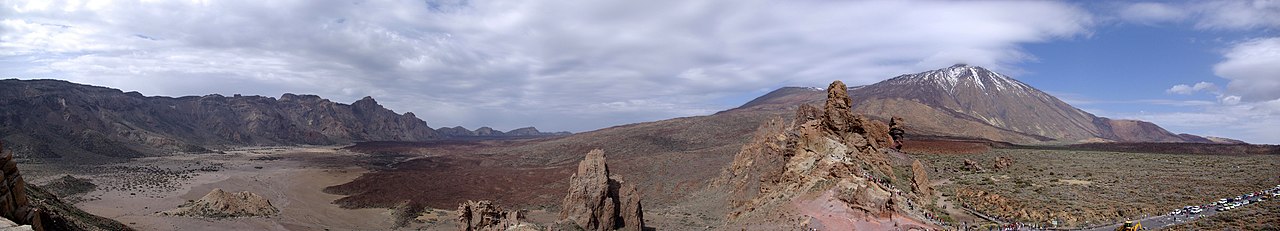
Mnt Teide ( Teneriffe)
related free online sources:
VOLCANOES:
"Eruptions that shook the world"
a very interesting and freely avaible source how volcanoes work where you find all what you want to know about volcanoes
Sources of the volcanic activity at El Hierro ( since 2011):
Some may like to read a review on the volcanic activity below El Hierro in 2011:
Here is a data based report by earthquake .com- an excellent site regularly reporting (what you never get in the news) about Earthquakes and related volcanism
worldnews.com: Special environmental reports about the Canaries
Miscanellous:
Geschichte Teneriffas (deutsch)

Fataga ( Gran Canaria)

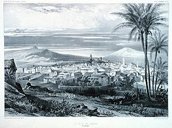
San Cristóbal de La Laguna in 1880 (Tenerife)

Caldera de Taburiente National Park (La Palma).

Garajonay (La Gomera)
(BBC/ 20111204)Canary Island volcano: A new island in the making?
Keine Kommentare:
Kommentar veröffentlichen