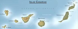
CANARY ISLANDS- ISLAS CANARIAS- KANARISCHE INSELN | ||||||||||||||||||||||||||||||||||||||||||||||||||||||||||||||||||||||||||||||||||||||||||||||||||||||||||||||||||||||||||||||||||||||||||||||||||||||||||||||||||||||||||||||||||||||||||||||||||||||||||||||||||||||||||||||||||||||||||
 BLOG/ Startseite | ||||||||||||||||||||||||||||||||||||||||||||||||||||||||||||||||||||||||||||||||||||||||||||||||||||||||||||||||||||||||||||||||||||||||||||||||||||||||||||||||||||||||||||||||||||||||||||||||||||||||||||||||||||||||||||||||||||||||||
| internal links > | START | HOME | SOLAR BLOG | VOLCANO WATCH | VOLCANO MAPS | external links > | IGN | AVCAN | AVCAN/ fb. | EMSC | GVP | NOAA |
Activity report here will ony follow, if new events take place. For other environmental reports, please visit the solar and terrestrial blog on my homepage
-------------
APRIL 21- 2016:
A major quake occured surprisingly enough on April 21 offshore northwest of El Hierro ( Valverde region). The quake had a magnitude of M 4.2. and happened in about 30 km depth.-Due to the El Hierro blogspot- the quake was slightly felt on El Hierro and on La Palma. No damage was reported so far.

was very quiet, with just some minor quakes from time to time, mostly at the edge of the Canary caldera
Two shallow quakes were registered on February 22 and 23 2016- indicating that magma comes closer to the surface on Teneriffe and El Hierro . The fact , that the sea floor around the canaries is in an average depth of about 3500 meters below zero and these magmatic quakes occure on higher ground , indicates, that the caldera a is as sealed by sediments as suggested and poses more resistance to that magma than the islands formations. This would make - due to the current microquakes- an eruption on the islands of Tenerife or El,Hierro rather likely than an subsea eruption around the islands- what is still the hope of the most Spanish experts .
However., The process gets as slower as more as the magma comes towards the surface,. The earth is around sphere in such the space where magma still can rund to and fill holes and cracks gets more/ widens towards its surface . I don`t know, when it will finally will come to a surface eruption, But as long the magmatic intrusion goes on - as just these microquakes but also the ongoing tremors indicate, this is not a question wether, but just when it happens.
With the current and lower speed , this might take until the middle of 2016 or even longer but might happen at any time in the next month as soon as this magma gets in contact with an higher amount of seawater, what would change the hot fluid gasless and so NOT explosive mantle magma to explosive materials
Such an eruption might first me violently and possible occure along with a pyroclastic emission, as magma will likely mix at any height water within the old volcano channels, but go on then likely just as an intensive lava flow and (due to the the reports of previous eruptions on Teneriffe such as the last known one in the 18th century) with much of smoke .
Imminent danger is indicated, if there is any steam emission visible coming out of any spots on the ground, where it not was before and/ or if the ground becomes significantly warmer or begins to shiver (surface tremors) .If that occurs , this place and the entire island should--as I would suggest- imidiately be left resp. evacuated.
 < El Hierro/ 20160226

.one of the few earthquakes around the Canaries, that was felt on the surface:
people reported on EMSC:
(Witness location : El Cotillo (Spain) (15 km NE from epicenter): "It sounded like a large vehicle had crashed into our building. There was a loud bang, like a thunder clap and the building shook"
Witness location : La Oliva (Spain) (16 km NE from epicenter): "Deep rumbling and vibration for 5 to 8 seconds..."
Witness location : Corralejo (Spain) (29 km NE from epicenter): "Felt nothing in Corralejo, Fuerteventura"
-------------
APRIL 21- 2016:
A major quake occured surprisingly enough on April 21 offshore northwest of El Hierro ( Valverde region). The quake had a magnitude of M 4.2. and happened in about 30 km depth.-Due to the El Hierro blogspot- the quake was slightly felt on El Hierro and on La Palma. No damage was reported so far.
| Evento | Fecha | Hora(GMT)* | Latitud | Longitud | Prof. (km) | Int. Máx. | Mag. | Tipo Mag. (**) | Localización | Info |
| ign2016huaf | 20/04/2016 | 13:34:25 | 27.9874 | -17.9250 | 26 | III | 4.2 | mbLg | N VALVERDE.IHI | [+] |
| ign2016hszn | 20/04/2016 | 00:05:23 | 28.0406 | -16.2084 | 7 | 1.5 | mbLg | ATLÁNTICO-CANARIAS | [+] | |
| ign2016hsxt | 19/04/2016 | 23:12:20 | 28.2002 | -16.2523 | 11 | 1.8 | mbLg | ATLÁNTICO-CANARIAS | [+] | |
| ign2016hsgd | 19/04/2016 | 14:18:10 | 28.0697 | -16.1695 | 6 | 2.0 | mbLg | ATLÁNTICO-CANARIAS | [+] | |
| ign2016hoii | 17/04/2016 | 10:52:11 | 28.0617 | -16.1860 | 1.8 | mbLg | ATLÁNTICO-CANARIAS | [+] | ||
| ign2016hlwm | 16/04/2016 | 02:35:58 | 27.5297 | -16.4795 | 42 | 2.5 | M(mb) | ATLÁNTICO-CANARIAS | [+] | |
| ign2016hkbv | 15/04/2016 | 03:01:30 | 29.5675 | -14.7787 | 40 | 2.5 | mbLg | ATLÁNTICO-CANARIAS | [+] | |
| ign2016hcwa | 11/04/2016 | 04:08:20 | 28.3241 | -16.7543 | 13 | 1.5 | mbLg | SE EL TANQUE.ITF | [+] |
TREMORS:
Tremors are still rather low /weak and were today -at time of this update-relatively strongest on Gran Canaria

-------------------------------
MARCH 2016:
was very quiet, with just some minor quakes from time to time, mostly at the edge of the Canary caldera
FEBRUARY- 26- 2016:
However., The process gets as slower as more as the magma comes towards the surface,. The earth is around sphere in such the space where magma still can rund to and fill holes and cracks gets more/ widens towards its surface . I don`t know, when it will finally will come to a surface eruption, But as long the magmatic intrusion goes on - as just these microquakes but also the ongoing tremors indicate, this is not a question wether, but just when it happens.
With the current and lower speed , this might take until the middle of 2016 or even longer but might happen at any time in the next month as soon as this magma gets in contact with an higher amount of seawater, what would change the hot fluid gasless and so NOT explosive mantle magma to explosive materials
Such an eruption might first me violently and possible occure along with a pyroclastic emission, as magma will likely mix at any height water within the old volcano channels, but go on then likely just as an intensive lava flow and (due to the the reports of previous eruptions on Teneriffe such as the last known one in the 18th century) with much of smoke .
Imminent danger is indicated, if there is any steam emission visible coming out of any spots on the ground, where it not was before and/ or if the ground becomes significantly warmer or begins to shiver (surface tremors) .If that occurs , this place and the entire island should--as I would suggest- imidiately be left resp. evacuated.
| Evento | Fecha | Hora(GMT)* | Latitud | Longitud | Prof. (km) | Int. Máx. | Mag. | Tipo Mag. (**) | Localización | Info |
| ign2016duzp | 24/02/2016 | 04:15:27 | 27.6338 | -18.1198 | 22 | 2.4 | mbLg | SW EL PINAR.IHI | [+] | |
| ign2016ducf | 23/02/2016 | 16:26:17 | 27.7033 | -18.0107 | 3 | 2.0 | mbLg | W EL PINAR.IHI | [+] | |
| ign2016dsrb | 22/02/2016 | 21:40:08 | 28.1046 | -16.2142 | 4 | 1.7 | mbLg | ATLÁNTICO-CANARIAS | [+] | |
| 1374335 | 16/02/2016 | 00:23:21 | 27.8033 | -18.1569 | 35 | 2.7 | mbLg | NW FRONTERA.IHI | [+] |
TREMORS:
Tremors are still present , magnitudes rather low but meanwhile rather equally on all islands. The seimsographs on Teneriffe and Lanzerote are out od functionat time of this update .
 < El Hierro/ 20160226
-------------------------------
20160110: M 3.5 M earthquake rocks Fuerteventura/ Canary Island.
.one of the few earthquakes around the Canaries, that was felt on the surface:
people reported on EMSC:
(Witness location : El Cotillo (Spain) (15 km NE from epicenter): "It sounded like a large vehicle had crashed into our building. There was a loud bang, like a thunder clap and the building shook"
Witness location : La Oliva (Spain) (16 km NE from epicenter): "Deep rumbling and vibration for 5 to 8 seconds..."
Witness location : Corralejo (Spain) (29 km NE from epicenter): "Felt nothing in Corralejo, Fuerteventura"
recent activity:
| Evento | Fecha | Hora(GMT)* | Latitud | Longitud | Prof. (km) | Int. Máx. | Mag. | Tipo Mag. (**) | Localización | Info |
| 1360633 | 14/01/2016 | 21:19:00 | 27.7613 | -18.1313 | 16 | 2.5 | mbLg | NW FRONTERA.IHI | [+] | |
| 1360312 | 13/01/2016 | 13:13:42 | 28.8621 | -14.6377 | 15 | 2.3 | mbLg | ATLÁNTICO-CANARIAS | [+] | |
| 1360168 | 12/01/2016 | 21:39:10 | 28.0972 | -16.3466 | 1.5 | mbLg | SE ARICO.ITF | [+] | ||
| 1360054 | 11/01/2016 | 21:34:35 | 28.2554 | -15.8062 | 1.8 | mbLg | ATLÁNTICO-CANARIAS | [+] | ||
| 1359878 | 10/01/2016 | 20:22:06 | 28.6009 | -14.1494 | 11 | III | 3.3 | mbLg | ATLÁNTICO-CANARIAS | [+] |
| 1359859 | 09/01/2016 | 12:45:04 | 28.1568 | -16.1923 | 21 | 2.7 | mbLg | ATLÁNTICO-CANARIAS |
TREMORS:
Tremors were persistent on all islands. The seismograph on La Palmashows shows electric disturbances- similar to those observed in the first quarter of 2014 on Teneriffe after the third activity phase had begun in December 2013.
 < La Palma/ 20160117
 < La Gomera/ 20160117
TREMORS:
Tremors were persistent on all islands. The seismograph on La Palmashows shows electric disturbances- similar to those observed in the first quarter of 2014 on Teneriffe after the third activity phase had begun in December 2013.
 < La Palma/ 20160117
 < La Gomera/ 20160117
GOOGLE BLOG ARCHIVE |
Seitenzahl: 03 |
| Latest Post |
| BLOG START/ NAVI |
useful links/ nützliche Links: |
| EMSC |
| Global Volcanism Program |
| Facebook Seite der AVCAN |
| IGN (Spain) Serie El Hierro |
| Volcano-discovery.com |
| Earthquake- report. com |
MEDIEN: |
KARTEN: |
SOLAR (SAT) |
SOLAR (info) |
REAL TIME FEATURES:
(click on the images to enlarge them
MODVOLC/ TENERIFE:

(click on the images to enlarge them
MODVOLC/ TENERIFE:
MODVOLC/ EL HIERRO:

Bebenmap( El Hierro)

GPS deformation measure stations on El Hierro

MODVOLC/ Hawaii thermal alerts:
^
near real time thermal alert
for El Hierro, la Palma, Teneriffe and la Gomera ( updated once per week)
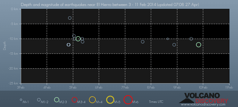
volcano discovery. com : Earthquake within 30 km radius around El Hierro:
-------
---------------
previous posts those contain articles about the Canary volcanism in general:
February 10- 16- 2014
January 15- 19- 2014
January 20- 27- 2014

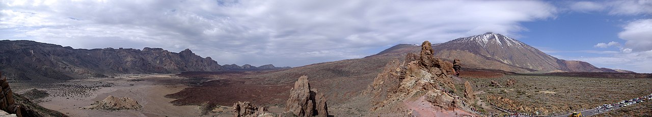
Mnt Teide ( Teneriffe)
related free online sources:
VOLCANOES:
"Eruptions that shook the world"
a very interesting and freely avaible source how volcanoes work where you find all what you want to know about volcanoes
Sources of the volcanic activity at El Hierro ( since 2011):
Some may like to read a review on the volcanic activity below El Hierro in 2011:
Here is a data based report by earthquake .com- an excellent site regularly reporting (what you never get in the news) about Earthquakes and related volcanism
worldnews.com: Special environmental reports about the Canaries
Miscanellous:
Geschichte Teneriffas (deutsch)

Fataga ( Gran Canaria)

San Cristóbal de La Laguna in 1880 (Tenerife)

Caldera de Taburiente National Park (La Palma).

Garajonay (La Gomera)

(BBC/ 20111204)Canary Island volcano: A new island in the making?
:
Keine Kommentare:
Kommentar veröffentlichen