-->
:
:
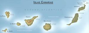
CANARY ISLANDS- ISLAS CANARIAS- KANARISCHE INSELN | |||||||||||||||||||||||||||||||||||||||||||||||||||||||||||||||||||||||||||||||||||||||||||
BLOG/ Startseite
FEBRUARY 10- 16 2014
| |||||||||||||||||||||||||||||||||||||||||||||||||||||||||||||||||||||||||||||||||||||||||||
 |
Activity report here will ony follow, if new events take place. For other environmental reports, please visit the solar and terrestrial blog on my homepage
-----------------------------------------------Activity reports 10 - 16. February 2014:Sunday- February 16 2014
No magmatic quakes below El Hierro since February 12. But tremors on the island increased sinceFebruary 15:
 < El Hierro/ 20140215 < El Hierro/ 20140215 < El Hierro/ 20140215 < El Hierro/ 20140215
WOW! IGN - so the German El Hierro blogspot- published its first bulletin since the new activity began in December 2013:
There is no link to this article on El Hierro blogspot1, but the author translated it at leat into German: Nothing new so far and no speculation on anything ., but just a kind of summary:
(translated ) "A new phase of magmatic reactivation occured in December 2013. 280 quakes were recorded since then, mainly near the El Pinar sation in the south east of the island. 14 of these quajes reportedly were felt by inhabitants. The M 5.1 quake on December 27, 9 km off the coast of northeastern El Hierro was also felt on the aneighbored islands. Related to this activity, the island of El Hierro deformed with a total of 9 cm in horizontal and with 4 cm in vertical direction during this activity phase. Since End of December these values remained stable. THe total vertical upflift since begin of the activity in 2011 is 20 cm."
Note: NOTHING IS KNOWN ABOUT, WHETHER NOT ALSO OTHER ISLANDS HAVE ANY DEFORMATION!
Since the new activity began in 2011 after 2.500 years, all experts and media focussed only on El Hierro . So, also GPS measure stations were only installed there...
Still (m) any questions?
some have...
There is still a ferior along the atlantic coast that any eruption might happen on La Palma island. Just on February 16, the wellknown online journal Carribbean 360 just republished the "MegaTsunami hybe", we so oftenly already have heard from british Geologists:( "recorded" might be overexeggerated, since all experts otherwise always hold on to the "pragmatism rule Nr 1": " Just report what you can see and measure so you can`t go wrong" "Caribbean faces threat of biggest tsunami ever recorded"Read more: http://www.caribbean360.com/index.php/news/1106618.html#ixzz2tTckwQcV My personal opinion about that: I don`t think the new hot spot activity must necessarily be related to an eruption on El Palma`s cumbre veja volcano group . I would rather assume, that the volcanoes on all islands (except El Hierro) are not "finally dead" , but not connected to the mantle plume and the supposed primary deep magmachamber in 8- 16(+) km depth anymore. The ( comparable) little volcanism that still occcurs there from time to time today - is- so also say the Spanish volcanologists more likely related to fissures and cracks in the Earth mantle below the islands, through those then magma can rise from time to time up to empty spaces within this upper caldera, where it can mix then with explosive ingredients such as water( steam) what causes the minor eruptions observed during the past centuries. In other words: As there is no common upper magma chamber anymore, that once connected all the volcanoes on the islands, when these, what I strongly suppose were still random craters on the egde of a giant shield volcano between todays Canaries and the African coast. Without an closed magmachamber no pressure can built up anywhere below the islands, that could bring the magma finally up to the surface there. The only thinkable scenario would also be the worst of worst cases An eruption from the possibly or or probably still intact PRIMARY magmachamber in more than 8 km depth! This - due to expert and new experiments could happen, if that magmachamber is 1. large enough (= has with more than 240 cubicmiles the seize of a common supervolcano) and 2. would fill completely ( what requires enough activity , resp magma rising up all along from the earth mantle in estimated more than 70 km depth (so spanish geologists t, what would also mean that the african boundary has the thickest earth crust on the world ) ) If filled completely the pressure on top of the magmachamber finally then would become so big that the Earth crust above cannot contain it anymore. The consequences of such an formally supervolcano eruption - (allthough the oceanic crust would explode underwater) - as I would imagine- would be likely apocalyptic, that noone would be sure along the entire Atlantic coast, where ever you are. here the video I have posted in earlier blogs: ( its just a copy of an clip by Prof Steven Hawking) (watch also the excellent documentary on the research on the yellowstone caldera as posted on the bottom of this page,. This documentary is very helpful better to understand the Canary hotspot) Since 2013 all quakes and magmatic movements occured in a depth of more than 10 km and magma actually never really rose further upwards since then . The problem is: there is no technical mean to localise, to monitor or to find out what actually happens in this depth . If such an eruptions from this depth should occure ( what really would be the worst of all worst thinkable options) there will be indicators before. Its just depends on us, whether we will understand them right in time. Have a nice week! ------------------ Wednesday- February 12 2014
update/ 21 UTC:
Evento | Fecha | Hora(GMT)* | Latitud | Longitud | Prof. | (km) Int. Máx. | Mag. | Tipo Mag. (**) | Localización | Info | 1257977 | 12/02/2014 | 18:37:38 | 27.7681 | -18.1738 | 18 | 1.7 | mbLg | W FRONTERA.IHI | [+] | update/ 7:00 UTC:
two minor hic hocs from the mantle plume below El Hierro
TREMORS:
All seismographs online. No increase on El Hierro. Signals are also low on La Palma and Teneriffe,
stronger on La Gomera, Fuerteventura and Lanzarote and relatively highest on Gran Canaria:
 < GranCan/ 20140212 < GranCan/ 20140212
still no deformations data available for February 2014
The frequencies measured on all island are analog to the tremors and show , that magma is mainly present below the eastern islands of the archipelago. The red bottom line however is strongest below El Hierro

^El Hierro/ 20140212
-----------------------
Monday- February 10- 9:53 UTC:
A M 3.4. quake occured today about 1 km off the northwestern coast of La Palma Island. Some houses near the coast reportedly were swaying, but no damages were reported. La Palma is not in an subduction but in a stretching zone. With its depth of 40 km near the earth mantle, this quake seems rather to come from a crack that widens in the depth . So far- nothing directly volcanic, allthough there always is the possibility, that also magma rises up through those geological fissures.
 here the EMSC report: M 3.5 - CANARY ISLANDS, SPAIN REGION - 2014-02-10 05:56:49 UTC  TREMORS: All islands have moderate harmonic tremors, including La Palma , that might have increased a bit ober the past days, They are still relatively strongest on the eastern islands Gran Canaria, Fuerteventura and Lanzerote, Also, the seismigraph Gomera has recorded the quake on La Palma: Its interesting to compare the amplitude of the M 3.4 quake to the strength of usual tremor signals:  - activity reports- end- -------------------------- ---------------------This weeks subject:THE CANARY ISLANDS IN MYTHOLOGYthere are several sources in mythology those might have been related to the Canary islands:
The most known one is the saga of Atlas and its doughters, the seven Hesperides, by many believed to be a parabel interprated as Atlas- The mountain- brought forth 7 doughters- the Canary Islands.
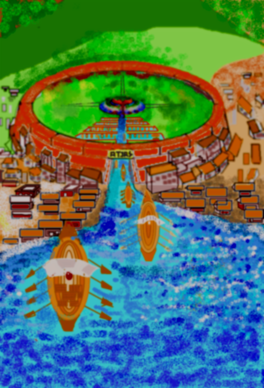
so first question is: Who is Atlas?In Mythology there are two figures named Atlas .1. The primordial Titan named Atlas: (wikipedia)) In Greek mythology, Atlas (/ˈætləs/; Ancient Greek: Ἄτλας) was the primordial Titan who held up the celestial sphere. He is also the titan of astronomy and navigation. Although associated with various places, he became commonly identified with the Atlas Mountains in northwest Africa (Modern-day Morocco and Algeria).[1] Atlas was the son of the Titan Iapetus and the Oceanid Asia[2] or Klyménē (Κλυμένη):[3 Atlas and his brother Menoetius sided with the Titans in their war against the Olympians, the Titanomachy. When the Titans were defeated, many of them (including Menoetius) were confined to Tartarus, but Zeus condemned Atlas to stand at the western edge of Gaia (the Earth) and hold up Uranus on his shoulders, to prevent the two from resuming their primordial embrace. 2. KING ATLAS OF ATLANTIS (Platon/ Kritias dialog aus TImaios) Egyptian myth according to Platos TImaios refers another man named Atlas as a son of Poseidon, who was the first king of the island of Atlantis, a large continental island beyond the columns of Hercules" as Platon reports (what means Gibraltar). If it really has existed once , it was situated - as believed by the most (including myself) most likely right in the middle of the Atlantic. maybe rather a little bit more to North. In the South of the island , King Atlas due to Plato- transformed the landscape into a large facility out of three ringformed walls with the life giving two springs and a sanctuary in the upper one , form where the water then could flow on after another through the second and third rings below , in those then all types of plants grew best . There facility was built to serve as a kind of botanical garden in which" all plantes were cultivated we still know and eat today" and where also animals grew up resp were cultivated. two smaller islands were associated to Atlantis from those other continents easily could reached by sailing boats   After been happy for many years , the Atlantians began to disobey the laws of the Gods. They also mixed with humans,by what their offspring became evil animal like and began to misuse their abilities and knowledge . the first drawings I made on a computer was a reconstruction of the court KIng Atlas built around the two springs on the height in the middle of Atlantis. Platon described very exactly even the measures of the three rings, Atlas due to Platon formed , each surrounded by a river flowing off form both springs , form where the water then flew further into the next ring below , within these huge rings all types of plants were cultivated as well as all animals we know and eat until today " remark: all the graphics below were made according to the detailed measures (measure units at that time were socalled Greek "stadions") as described ib Platons TImaios: 
^Atlantis at time of King Atlas
acacording to Plato, at the time when the offspring of Atlantis`s foremost so godlike inhabitants became more and more aggressive, ugly and evil, the later kings of Atlantis reinforced first the inner ring and then also the outer third oner with higher walls . The original garden in the lowest ring , that has grown there since times of King Atlas was replaced with a port for their trading (rather: military) ships,. Large caves with strong gates were carved into this outer ring through those the ships could enter the court district and were also safe forkm bad weather and enemies Only a large enforced and well garded gate led from this high outer wall into the court with Atlas? s sanctuary and his old gardens inside.A channel connected th facility with the sea:

Later, the Atlantian kings built another even higher wall in a larger distance around the entire fortress (the inner round form on the image below) , More place for ships was built along the channel that led from the fortress to the new outer wall and from there than further to the sea.
Still so Plato Atlantis was frequented or rather occupied by a "rising number of foreign traders" from those many then settled down on thenisland and built villages and houses around the outer wall of the fortress.
So the entire facility (in the beginning only the botanical garden af Atlas without reinforced walls and military ships) - according to Plato- must have looked like- towards the end of its days, shortly before it surrender:
...
At the begin of its telling, Plato refers to the Eypt priest Solon ( from whom the entire story originally was told to Platon ) saying , that " in long time intervals, the course of celestial bodies create periodical catastrophies on Earth such as earthquakes and large floodings. ( whereby he possibly means that the volcanic Island of Atlantis he desribes with a "cold and a hot spring right in its middle" surrendered by a seldom natural catastrophy . ( ancient myth such as the Titanomachie by Hesiod tell about incredible natural forces (identified as " hundred armed giant form the depth" "and entire mountains been thrown through the air) stories so incredible that already ancient readers who heard these old stories obvioulsy than first began to believe those incredible deeds can only be done by gods with supernatural forces ( today we would rather think on extraterrists. Thinkable as a reason for total destruction would be (differently to an volcano eruption) a volcano explosion by hydrogen and other gases as it once in history reportedly occured with the Greek island of Thera (Santorin) 1500 B.C.) The surrender of Atlantis- so Platon was associated with a large quake or Tsunami in the mediterranean sea , while Atlantis had attacked or was going to conquer Eqypt : Due to Platon - during that battle, " The earth and sea opened and swallowed both-. the Egyptian and Atlantic warriors . The last of the three chapters describing the end of Atlantis once was lost and- unfortunately- never found again yet the second chapter ends with the words: "and Zeus spoke" The Titan Attas
Here is what wikipedia writes about the Hesperides:
In Greek mythology, the Hesperides (/hɛˈspɛrɪdiːz/; Ancient Greek: Ἑσπερίδες) are nymphs who tend a blissful garden in a far western corner of the world, located near the neighbourhood of Cyrene[1] or Benghazi[2] in Libya or the Atlas mountains inNorth Africa at the edge of the encircling Oceanus, the world-ocean.[3] The nymphs are said to be the daughters of Hesperus.[4]
in younger stories, the hesperides number only three. elöder ones number 7 Hesperides:

An ancient vase painting attests the following names as four: Asterope, Chrysothemis, Hygieia and Lipara; on another seven names as Aiopis, Antheia, Donakis, Kalypso, Mermesa, Nelisa and Tara.[18] Petrus Apianus attributed to these stars a mythical connection of their own. He believed that they were the seven Hesperides, nymph daughters of the Atlas. Their names were: Aegle, Erythea, Arethusa, Hestia, Hespera, Hesperusa and Hespereia.[19] In the far west of the world. Hesperides scene of the apotheosis of Heracles (romanised to Hercules) on a late fifth-century hydria by the Meidias Painter in London[20] They are sometimes called the Western Maidens, the Daughters of Evening or Erythrai, and the "Sunset Goddesses", designations all apparently tied to their imagined location in the distant west. Hesperis is appropriately the personification of the evening (as Eos is of the dawn) and the Evening Star is Hesperus. In addition to their tending of the garden, they were said to have taken great pleasure in singing.
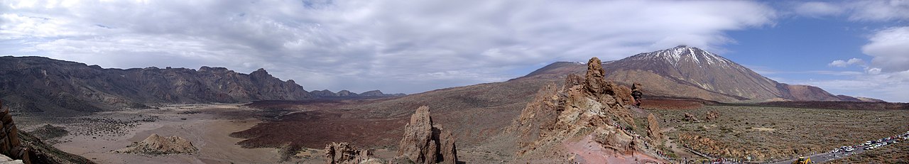
-----------HISTORICAL ERUPTIONS OF MT TEIDE: the last historical eruptions of Mnt. Teide took place in: 1492/ 1706- 08/ 1998; 1909 ( GVP). The activity period beginning in the early 18th century was the strongest activity on Mnt Teide reported in recent history. ( I recenbtly found an very instersting Guanches report on that I tried now to find again but could not yet find again. I will post that, as soon, as I should) Most interestingly this activity period with its last major event in 1798 occured occured at the same time when a similar eruption period is reported to have occured on iceleand, which was with the eruption of Mount Laki, that killed thousands in 1783, also likely the strongest in recent history. Further reading: Icelandic Volcano Caused Historic Famine In Egypt, Study ShowsThe latest activity report by the Global Volcanism Program for Mnt. Teide- a shorts yellow alert state-dates back to 2004:
Local volcanologists reported that there was increased seismicity at Tenerife in mid-May, according to a news article. The article stated that during several days before 18 May there were "five successive low-intensity earthquakes in the island's most volcanically active zone in the area between Mont Teide and Santiago del Teide." The director of the Estación Vulcanológica de Canarias stated that the earthquakes, which were less than M 2, could be an early sign that something unusual was happening at the volcano.
Yorkshire Post Today News( by Volcanolive/John Seach) 2005 Volcanic activity Volcanic unrest occurred at the volcano in January 2005. Carbon dioxide emissions rose from 75 to 354 tons per day, and hydrogen sulfide emissions rose from 35 to 152 tons per day. Seismic activity remained elevated under the volcano. Fumaroles increased in pressure, and emitted sounds. There was no significant ground deformation recorded. 2004 Earthquakes Seismic activity increased at the volcano during April and May 2004. Over 200 earthquakes from magnitude 1 to 3 were recorded, with three being felt by residents. Most earthquake epicenters were centred around the NW rift zone of Tenerife and in the strait between Gran Canaria and Tenerife. The earthquake crisis was probably related to dike emplacement at 3-4 km depth. --------------- --------
Ich habe beschlossen den Blog, bzw. zumindest die aktuellen Berichte in englischer Sprache fortzuführen. Mit Englisch lässt sich das alles einfacher kürzer und genauer ausdrücken. Deutsch ist besser zu verwenden für Dichtkunst oder um Geschichten zu erzählen,. Außerdem kann der Blog dann von mehr Menschen gelesen werden. Natürlich können Kommentare weiter in deutsch oder anderen Sprachen verfasst werden
This blog does not intend to give scientific advice or analysis. Its just wants to document the ongoing volcanic activity and the real events how they envolve, what might serve also as a basic for own conclusions.
Recently I decided to continue this blog - at least the activity updates and report- generally in English language. My English might not be perfect, but at least better than an automatic translator.Its easier to express anything in English than in German and it makes the blog easier understandable for international users. Special stories might be written in German. Comments can be posted in all languages, I recommend to use English, so comments are understandable for the most international visitors ---- some remarks about this blog: Generally also want to refer in this blog also to other interesting aspects of the Canaries, many people might not know yet. But- currently I want to document here the new and unexpected volcanic activity that began in 2011 , that has for itself many aspects, worth to review and tell about ---------
------------------
| |||||||||||||||||||||||||||||||||||||||||||||||||||||||||||||||||||||
REAL TIME FEATURES:
 Bebenmap( El Hierro)  ^ MODVOLC/ Hawaii thermal alerts near real time thermal alert for El Hierro, la Palma, Teneriffe and la Gomera ( updated once per week) volcano discovery. com : Earthquake within 30 km radius around El Hierro: 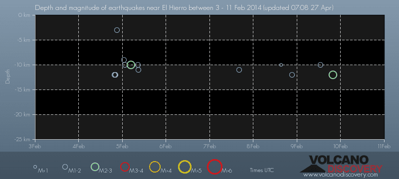 ------- --------------- previous weeks posts: January 15- 19- 2014 January 20- 27- 2014  Mnt Teide ( Teneriffe) related free online sources:VOLCANOES: "Eruptions that shook the world" a very interesting and freely avaible source how volcanoes work where you find all what you want to know about volcanoes Sources of the volcanic activity at El Hierro ( since 2011): Some may like to read a review on the volcanic activity below El Hierro in 2011: Here is a data based report by earthquake .com- an excellent site regularly reporting (what you never get in the news) about Earthquakes and related volcanism worldnews.com: Special environmental reports about the Canaries Miscanellous: Geschichte Teneriffas (deutsch)  Fataga ( Gran Canaria)  San Cristóbal de La Laguna in 1880 (Tenerife)  Caldera de Taburiente National Park (La Palma).  Garajonay (La Gomera)  (BBC/ 20111204)Canary Island volcano: A new island in the making? | |||||||||||||||||||||||||||||||||||||||||||||||||||||||||||||||||||||||||||||||||||||||||||
Keine Kommentare:
Kommentar veröffentlichen