-->
:
:
CANARY ISLANDS- ISLAS CANARIAS- KANARISCHE INSELN | |||||||||||||||||||||||||||||||||||||||||||||||||||||||||||||||||||||||||||||||||||||||||||||||||||||||||||||||||||||||||||||||||||||||||||||||||||||||||||||||||||||||||||||||||||||||||||||||||||||||||||||||||||||||||||||||||||||||||||||||||||||||||||||||||||||||||||||||||||||||||||||||||||||||||||||||||||||||||||||||||||||||||||||||||||||||||||||||||||||||||||||||||||||||||||||||||||||||||||||||||||||||||||||||||||||||||||||||||||||||||||||||||||||||||||||||||||||||||||||||||||||||||||||||||||||||||||||||||||||||||||||||||||||||||||||||||||||||||||||||||||||||||||||||||||||||||||||||||||||||||||||||||||||||||||||||||||||||||||||||||||||||||||||||||||||||||||||||||||||||||||||||||||||||||||||||||||||||||||||||||||||||||||||||||||||||||||||||||||||||||||||||||||||||||||||||||||||||||||||||||||||||||||||||||||||||||||||||||||||||||||||||||||||||||||||||||||||||||||||||||||||||||||||||||||||||||||||||||||||||||||||||||||||||||||||||||||||||||||||||||||||||||||||||||||||||||||||||||||||||
BLOG/ Startseite
week: March 01- 16- 2014
| |||||||||||||||||||||||||||||||||||||||||||||||||||||||||||||||||||||||||||||||||||||||||||||||||||||||||||||||||||||||||||||||||||||||||||||||||||||||||||||||||||||||||||||||||||||||||||||||||||||||||||||||||||||||||||||||||||||||||||||||||||||||||||||||||||||||||||||||||||||||||||||||||||||||||||||||||||||||||||||||||||||||||||||||||||||||||||||||||||||||||||||||||||||||||||||||||||||||||||||||||||||||||||||||||||||||||||||||||||||||||||||||||||||||||||||||||||||||||||||||||||||||||||||||||||||||||||||||||||||||||||||||||||||||||||||||||||||||||||||||||||||||||||||||||||||||||||||||||||||||||||||||||||||||||||||||||||||||||||||||||||||||||||||||||||||||||||||||||||||||||||||||||||||||||||||||||||||||||||||||||||||||||||||||||||||||||||||||||||||||||||||||||||||||||||||||||||||||||||||||||||||||||||||||||||||||||||||||||||||||||||||||||||||||||||||||||||||||||||||||||||||||||||||||||||||||||||||||||||||||||||||||||||||||||||||||||||||||||||||||||||||||||||||||||||||||||||||||||||||||
 |
Activity report here will ony follow, if new events take place. For other environmental reports, please visit the solar and terrestrial blog on my homepage
------------- ACTIVITY REPORTS:March 16 2014
Magma intrusion from the hot spot below El Hierro continued on March 16, but decreased both in number and intensity. Still no quake from depths lower than 12- 15 km and no signs of any surface activity. Allthough the sensiibility of the instruments was obvioulsy lowered, weak harmonic tremors ( caused by heat vibration of hot magma) are still present on all islands and are still relatively strongest on Gran Canaria:
 < GRANCAN/ 20140317 < GRANCAN/ 20140317
THE MODVOLC image from March 17 shows no visible bigh changes compared with the temperature signature observed during the previous week,, but seems to have increased slightly. Surface heat is still rerlatively highest around the Teide volcano massive and crater
----------March 15 2014
here first some updated informations about the related drift of the southern part of the african tectonic plate with its tow vectors (1) towards the west and towards the equator that effects as an continental pressure onto of the Canary towards the Northeast
THE AFAR DEPRESSION M 5.1 - OWEN FRACTURE ZONE REGION - 2014-03-15 02:59:29 UTC Interesting are also the frequent earthquake in the Owen fracture zone not far from the horn of Africa some southeast of the red sea and Afar triangle, where the African plate opens in a long ranging trench that leads through the entire Southern part of africa thatn is therefore expected to split oof from the Northern part at any time in the farer future. 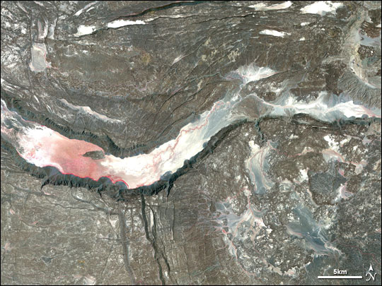 satellite image/ Afar trench satellite image/ Afar trench
The Afar Depression is the product of a tectonic triple junction (the Afar Triple Junction), where the spreading ridges that form the Red Sea and the Gulf of Aden emerge on land and meet the East African Rift ( wikipedia)
In February 2005 researchers found the trenchhad obviously begun to open with a much (1000 x) higher rate than before. ( 1 m/ year before 2005 and 1 meter or more since then) . What indeed was shown to them by the Ethiopians who live there, was a long about 16.- 20 meter trench leading throughout the country, and which obvioulsy suddenly opened resp had widened shortly before. I myself ( that is not the common and official opionion) strongly believe that a deep sudden crack that was going through the existing continental crack in late 2004 what was indeed has caused the 9.6 Magnitude Sumatra quake on Dec 26- 2004. This sudden event was likely caused by the immense expansion forces of magma that began rising up through the existing continental crack there at this time from the mantle below. the inbelievable expansion forces - created in mantle magma by the decreasing graviational forces widened the crack then, what lad then to a sudden movement of the southern part of the african quake which than transformed its energy ny the resistance this movement achieved on the boundary to the Indian plate that leads along the NE coast of Java and Sumatra. THE RELATIONSHIP BETWEEN SOLAR PROTON STORMS AND HOT SPOT ACTIVITIES / OR OTHER EVENTS OF MAGMATIC INTRUSION FROM THE EARTH`S MANTLE: Analysis showed : An entire serial or Protons storms had occured, beginning on Nov 11 2004 and ending with the last but strongest SEP on February 2005 (click here for the related NASA report) . Solar accelerated Protons (SAP or SEP) those hit the earth, interact with and move along the opposite ( negative/ > electrons) ) charged geomagnetic field lines through the earth body where their cinetic energy ( just caused by the acceleration from 20.000 km/ s up to a almost light velocity done by the initial solar SEP eruption ) is then by and by transformed INTO HEAT by friction with the dense earth core, until they finally slow them down until and integrate as the energyless mass particles they are into existing nuclear cores , This rising temperature of the earth mantle then presses regularly during proton storms magma upwards ( magma intrusion )on hot spots or in geological spreading zones. I have not to repeat, that we just also had another- this time medium intense but with almost 2 weeks VERY LONG LASTING- solar SEP event ( proton storms) just before the activity on the El Hierro hot spot increased again on March 14, which is just one in a long serial of SEPs those usually intensify around the maxima of the 11 years solar sun spot cycle such as 2012/213. This increased protons flux come in from the Sun dropped back to normal levels just on March 09 but the many protons those came in over these almost two weeks are still very active and have not finally slown done yet ..Click here, to find regular reports on those solar terrestrial activities on my website  << satellite based heat absorption signature at the begin of the recent proton storm on February 25 2014 (NASA- D- RAP) << satellite based heat absorption signature at the begin of the recent proton storm on February 25 2014 (NASA- D- RAP)EL HIERRO ACTIVITY TODAY :
the seimic magmatic swarm below El Hieero continued on March 15 2014 and intensified in number / frequency) and intensity. The average depth was about at 18 km with a range between 15 and 20 km. One single quake came from a depth of 6 km, but seems at the moment not to seem a first sign that magma rises up to the surface but rather an echoe to deeper quakes.
There is a low week tremor on all islands, the tremor intensity (standing for the vibrations the magma causes by its heat and be different gases it can mix with in differind depths) seems to decrease with the rising heat. Tremors are still relatively highest on Gran Canaria and is today second high on la Gomera.
---------------------
March 13- 14- 2014
A new and intensive earthquake swarm set in on March 14 with more than 25 quakes. The strongest since the new activity phase began in late December 2013. The microquakes all occured all below the el Golfo valley in The Northwest of El Hierro island massive and are related to a new magma intrusion from the hot spot below.
 There is no report yet about any surface activity:
TREMORS:
Tremors below all,island remained rather low. But again and similar as during earlier magma intrusions the earthquake swarm activity increased also near near Puerto Rico short,y after the activity increased below El Hierro: I have the suspicion that the force of uprising magma has effects onto the trenches in the atlantic causing a spreading there that causes pressure on the aneighbored Carribbean plate:
frist quake today happened there after 5 UTC:

---------------------
March 11- 12- 2014
another two quakes on March 12. The first quake below El Pinar / El Hierro was likely caused by new magma intrusion from the hot spot beölow th island
therelated epicenter map by IGN cannot be implemented and EMSC only records quakes above magnitude M 2.0. But I can leave you for today with a new 3 D bathymetric video scan of the volcano crater that formed offshore South of El Hierro at end of the first new activity phase in 2011: ) The intensified seismicc Earthquake along the Andreas fault that continues since January 08 2014 . This activity also increased following the minor but long lasting S1 proton storm that was triggered along with an an X 1.2 flare on February 27 and continued until March.7, with protons still active with the Earth s body and core. Seismic activity there peaked with a stronger 6.9 quake on March 09 followed by at least 50 afterquakes higher than M 3.0 on the same day and with a rise in average tremor activity there to M 3 level during then past days : M 6.9 - OFFSHORE NORTHERN CALIFORNIA - 2014-03-10 05:18:13 UTCM 4.4 - CENTRAL CALIFORNIA - 2014-03-13 02:11:04 UTC
also other regions in the USA are shaked by unusual earthquake activity such as the Oklahoma region in the central US, where a seismic swearm continues now also since weeks. Also the seismic activity in the Golf of Mexico is still on higher level after the strong eq swarm had begun in January 2014 ,
The frequent seismic activity along central American west coast also peaked with several stronger quakes those likely relate3d to the increased activity of the volcanoes Pacaya / Guatemala and Popcatepetl/ Mexico.
Find more about those current news in my solar an d terrestrial blog on my HP
------------------March 09- 10- 2014
Two minor quakes with shallow depth of 7 km occurred on March 09 and 10, the second on March 10 again between Teneriffe and Gran Canaria.
There is a suspicious sea mount which might become a volcano crater. The quake likely seems to be related to the hot spot activity. Its still very likely, that and " surface" eruption of any kind would- if- then occure subseas, where the resistance is lower
 TREMOR INTENSITY
increased again after March 07 with new magmatic intrusion and three new quakes below El Hierro on all,islands,. Tremors intensity on March 10 is strongest with almost equal levels on Gran Canaria , La Gomera and Fuerteventura:
 < GRANCAN/ 20140310 < GRANCAN/ 20140310-------------March 07- 08- 2014
The activity below El Hierro increased on March 08- likely a new boost of magma from the hot spot below.
 (EMSC) M 2.6 - CANARY ISLANDS, SPAIN REGION - 2014-03-08 01:33:07 UTC
TREMORS:
The stronger tremors obviously decreased on March 7 on all islands - allthough it seems, that the sensibility of the seismographs might have been changed as well . not the first time, as we know...
Tremors were and are relatively strongest on Gran Canaria:

One quake on March 07:
the quake was localised in a depth of 33 km between Gran Canaria and Fuerteventura
-----------------March 02- 04- 2014
The increased quake activity continued since February 27. Yet, most of these microquakes occured near to the hot spot below El Hierro. Withe the new activity since Feb 27 is , that several quakes occured between Teneriffe and Gran Canaria and beyond, westwards of Lanzerote. IGN still can`t or won`t tell, , in which depth the quake on Feb 27 occured , which was located directly below Teneriffe and near to the Teide volcano,
With depths of up to 80 km km the two quakes that occured most northwards , west of Lanzerote might be rather a result of deep tectonic movements.
The quakes those occured near the other islands are with 11- 20 km more shallow - and - as most observers conclude- very likely an indicator for a new magma imovements / and ntrusion:
 < location of the latest M 1.8 quake on Mar 03 in a dapth of 80 km < location of the latest M 1.8 quake on Mar 03 in a dapth of 80 km
TREMORS:
Harmonic tremors ars still present on all islands, and are relatively weakest on El Hierro and La Palma , become stronger towards the North East of the archipelago and are still strongest on Gran Canaria:
 < granCan/ 20140303- 04 < granCan/ 20140303- 04
MODVOLC:
There is no typical red colorisation on the MODVOLC Images of Fuerteventura and Lanzerote, what means that, the magmatic intrusion from the El Hierro hotspot does just not reach the eastern islands, but is limited to a area that ends in its northern extension at the boundaries of Teneriffe and GranCan. The magmatic pressure indeed seems to concentrate somewhere between Teneriffe and Gran Canaria , where - so I believe- any surface eruptiion ( if it should comes so far!!) likely would occure.
Heat signatures remained uequal on all islands since January 2014. Its difficult to judge the Modvolc thermal images so exactly , but I would say there was a slight increase on Teneriffe s thermal signature since the past week. I have falsely stored the first images in December 2013., so I can`t present the entire evolution since then. . But I can at least tell, , that heat signature on Teneriffe indeed by and by increased since the new volcanic activity began ion Dec 22- 26/ 2013 In January 2014 , the read colorisation was first only visible on the northern flank of Mnt. Teide., but crawled then afterwards slowly over the entire crater region and covers now the entire Teide summit:
---------------------------March 01- 2014
2nd update: another minor quake below El Hierro:
first update: One M 3.3 quake today, this time near the Northern Coast of Gran Canaria. The quake was very deep: its unlikely that it is in direct relation to the hot spot below El Hierro.
 TREMORS The marmonic tremors, those had increased on February 26, continued to be on higher level on all islands including El Hierro. Tremor is still strongest on Gran Canaria . The seismograph there obvioulsy also recorded numerous microquakes:  < Gran Canaria/ 20140301 < Gran Canaria/ 20140301 Thats all for today: The M 3.3 quake on February 27 west of Lanzerote was meanwhile localised in a depth of 46 kilometer. But still IGN could not tell the depth of the fare more interesting first M 2.1 quake that occured on February 27 on Teneriffe , below the Southeastern flank of the Teide massive near to the crater caldera . -------- ------ activity reports/ end --------------- -------- Über diesen Blog/ about this blog:
Ich habe beschlossen den Blog, bzw. zumindest die aktuellen Berichte in englischer Sprache fortzuführen. Mit Englisch lässt sich das alles einfacher kürzer und genauer ausdrücken. Deutsch ist besser zu verwenden für Dichtkunst oder um Geschichten zu erzählen,. Außerdem kann der Blog dann von mehr Menschen gelesen werden. Natürlich können Kommentare weiter in deutsch oder anderen Sprachen verfasst werden
This blog does not intend to give scientific advice or analysis. Its just wants to document the ongoing volcanic activity and the real events how they envolve, what might serve also as a basic for own conclusions.
Recently I decided to continue this blog - at least the activity updates and report- generally in English language. My English might not be perfect, but at least better than an automatic translator.Its easier to express anything in English than in German and it makes the blog easier understandable for international users. Special stories might be written in German. Comments can be posted in all languages, I recommend to use English, so comments are understandable for the most international visitors ---- some remarks about this blog: Generally also want to refer in this blog also to other interesting aspects of the Canaries, many people might not know yet. But- currently I want to document here the new and unexpected volcanic activity that began in 2011 , that has for itself many aspects, worth to review and tell about ---------
------------------
| ||||||||||||||||||||||||||||||||||||||||||||||||||||||||||||||||||||||||||||||||||||||||||||||||||||||||||||||||||||||||||||||||||||||||||||||||||||||||||||||||||||||||||||||||||||||||||||||||||||||||||||||||||||||||||||||||||||||||||||||||||||||||||||||||||||||||||||||||||||||||||||||||||||||||||||||||||||||||||||||||||||||||||||||||||||||||||||||||||||||||||||||||||||||||||||||||||||||||||||||||||||||||||||||||||||||||||||||||||||||||||||||||||||||||||||||||||||||||||||||||||||||||||||||||||||||||||||||||||||||||||||||||||||||||||||||||||||||||||||||||||||||||||||||||||||||||||||||||||||||||||||||||||||||||||||||||||||||||||||||||||||||||||||||||||||||||||||||||||||||||||||||||||||||||||||||||||||||||||||||||||||||||||||||||||||||||||||||||||||||||||||||||||||||||||||||||||||||||||||||||||||||||||||||||||||||||||||||||||||||||||||||||||||||||||||||||||||||||||||||||||||||||||||||||||||||||||||||||||||||||||||||||||||||||||||||||||||||||||||||||||||||||||||||||||||||||||||||||||||||
REAL TIME FEATURES:
 Bebenmap( El Hierro)  ^ MODVOLC/ Hawaii thermal alerts near real time thermal alert for El Hierro, la Palma, Teneriffe and la Gomera ( updated once per week) volcano discovery. com : Earthquake within 30 km radius around El Hierro: 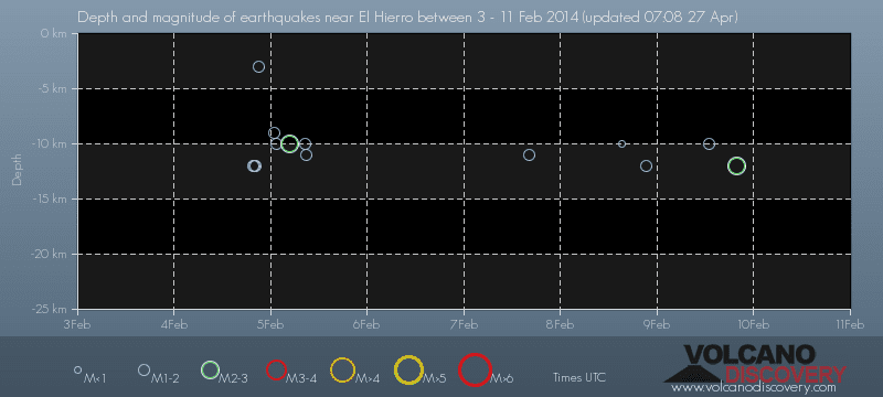 ------- --------------- previous posts those contain articles about the Canary volcanism in general:February 10- 16- 2014 January 15- 19- 2014 January 20- 27- 2014  Mnt Teide ( Teneriffe) related free online sources:VOLCANOES: "Eruptions that shook the world" a very interesting and freely avaible source how volcanoes work where you find all what you want to know about volcanoes Sources of the volcanic activity at El Hierro ( since 2011): Some may like to read a review on the volcanic activity below El Hierro in 2011: Here is a data based report by earthquake .com- an excellent site regularly reporting (what you never get in the news) about Earthquakes and related volcanism worldnews.com: Special environmental reports about the Canaries Miscanellous: Geschichte Teneriffas (deutsch)  Fataga ( Gran Canaria)  San Cristóbal de La Laguna in 1880 (Tenerife)  Caldera de Taburiente National Park (La Palma).  Garajonay (La Gomera)  (BBC/ 20111204)Canary Island volcano: A new island in the making? | |||||||||||||||||||||||||||||||||||||||||||||||||||||||||||||||||||||||||||||||||||||||||||||||||||||||||||||||||||||||||||||||||||||||||||||||||||||||||||||||||||||||||||||||||||||||||||||||||||||||||||||||||||||||||||||||||||||||||||||||||||||||||||||||||||||||||||||||||||||||||||||||||||||||||||||||||||||||||||||||||||||||||||||||||||||||||||||||||||||||||||||||||||||||||||||||||||||||||||||||||||||||||||||||||||||||||||||||||||||||||||||||||||||||||||||||||||||||||||||||||||||||||||||||||||||||||||||||||||||||||||||||||||||||||||||||||||||||||||||||||||||||||||||||||||||||||||||||||||||||||||||||||||||||||||||||||||||||||||||||||||||||||||||||||||||||||||||||||||||||||||||||||||||||||||||||||||||||||||||||||||||||||||||||||||||||||||||||||||||||||||||||||||||||||||||||||||||||||||||||||||||||||||||||||||||||||||||||||||||||||||||||||||||||||||||||||||||||||||||||||||||||||||||||||||||||||||||||||||||||||||||||||||||||||||||||||||||||||||||||||||||||||||||||||||||||||||||||||||||||
Keine Kommentare:
Kommentar veröffentlichen